GOECHALA TREK
GOECHALA TREK
INR 18,500/-
Per person
11 Days and 10 Nights
FACILITIES
Accommodation

Transportation included
Safety gears
100% Safety
assured
Certified Guide
Trekking gear
Overview
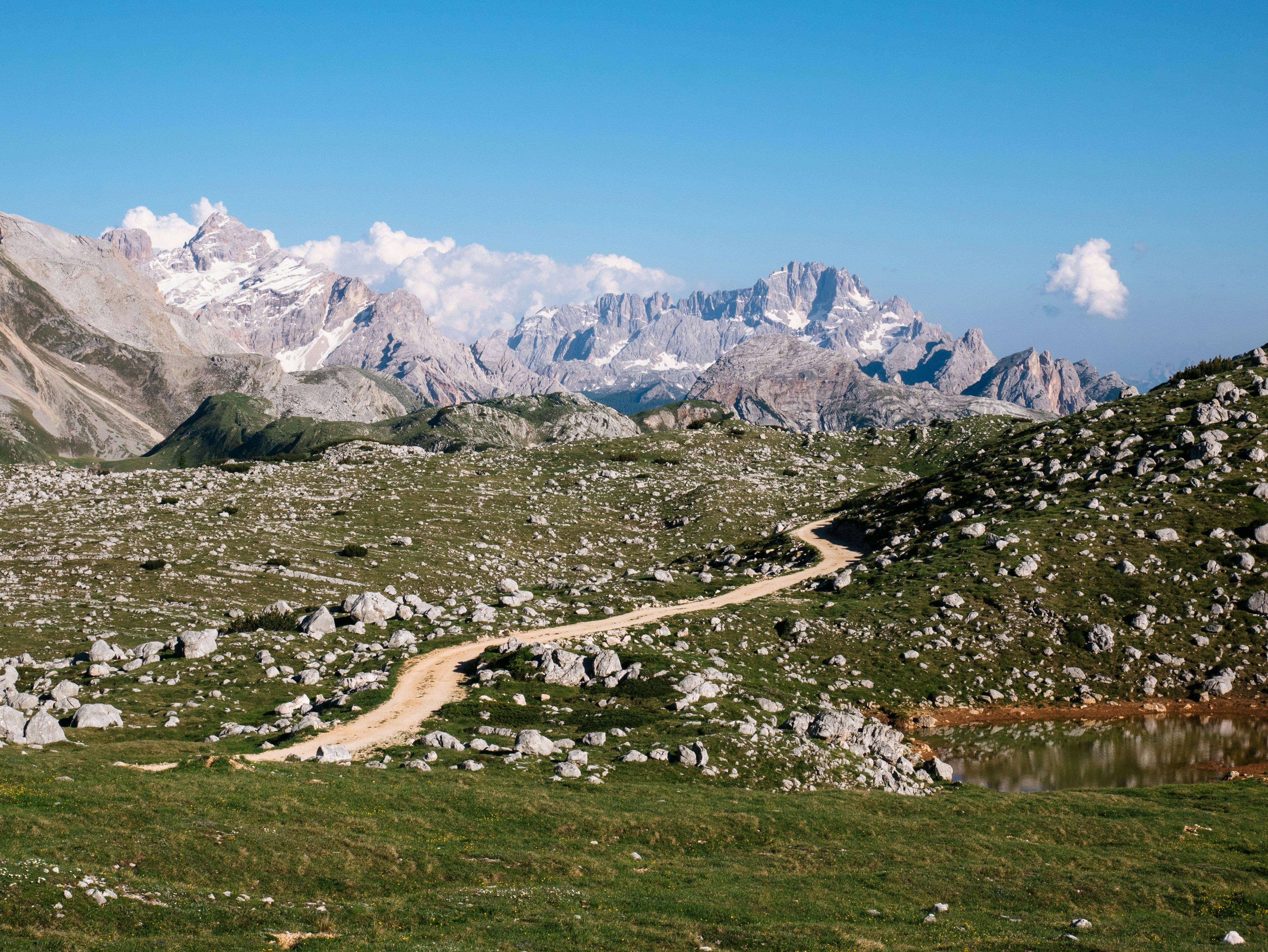
The Goechala trek is a thrilling and challenging adventure that offers trekkers an opportunity to explore the captivating landscape of the Eastern Himalayas. Located in the picturesque state of Sikkim, this trek is a perfect blend of natural beauty and adventure.
The trek begins at the charming town of Yuksom, which is famous for its rich history and cultural significance. The trail takes you through dense forests, serene rivers, and beautiful valleys, and culminates at the stunning Goechala Pass, situated at an altitude of 16,207 feet.
As you trek through the enchanting landscape, you'll be mesmerized by the breathtaking views of Mt. Kanchenjunga, the third-highest mountain in the world. The trek also offers trekkers an opportunity to witness the diverse flora and fauna of the region, including rare species of birds and animals.
AdvenThrill, the safest and most responsible outdoor adventure company in India, offers a meticulously planned Goechala trek that ensures trekkers' safety and comfort while providing an unforgettable adventure experience. Our experienced and certified trek leaders will guide you through the trail, and our support staff will ensure that you have a hassle-free and enjoyable trek.
At AdvenThrill, we prioritize the safety of our trekkers and adhere to the highest standards of responsible tourism. We follow Leave No Trace principles to minimize our impact on the environment and promote sustainable tourism. Our well-equipped campsites and nutritious meals ensure that you have a comfortable stay while trekking in the rugged Himalayan terrain.
Join AdvenThrill's Goechala trek and embark on an adventure of a lifetime, immersing yourself in the natural beauty of the Himalayas while experiencing the thrill of trekking at high altitudes. Contact us now to book your trek and create unforgettable memories in the lap of the Himalayas.
Itinerary
Day 1 - New Jalpaiguri (NJP) to Yuksom
Altitude: 5700 ft.
150 km drive, approx 8 hours.
Pick-up at 10am NJP railway station (Travel cost inclusive.)
Pass through Police Check Post at Melli. Foreigners need Inner Line Permit (ILP) – the driver will help get it. Procedure takes half-an-hour.
From NJP to Melli (at the border of Sikkim and West Bengal.)
Lunch break at Jorthang.
Last ATM at Legship .
Base camp at Yuksom. Overnight in guest house
Day 2 - Yuksom to Sachen
Altitude: 7200 ft.
8 kms trek, approx 6 hrs.
No shops on the trail. Erratic telecom network. Abundant water sources.
Have packed lunch en route.
Trail through dense forests, with frequent ascent and descent.
After half-an-hour walk from Yuksom, you can see Tshokha.
Trail passes through three iron bridges (Gradual ascent till the first bridge, steep ascent for 20 min then gradual descent till second bridge and gradual ascent till third bridge. Walk for half an hour to the camp site.
Be careful on trails as it stays busy with animals like yak and mules. Make way for the animals by sticking to the mountain side.
Sachen campsite is in the forest, so accommodation in tents.
Day 3 - Sachen to Tshokha via Bakhim
Altitude: Bakhim at 8600 ft and Tshokha at 9700 ft
7 kms trek, approx 5 hrs
Pleasant walk till the last iron bridge (1 km from Sachen)
Steep ascent till Bakhim - spot peaks like: Mt. Pandlm, Tenzinkhay
Enjoy tea and refill water at Bakhim
Bakhim to Tshokha - 2kms trek
Trail lined with Rhododendron and Alpine berries
Lunch at campsite
Overnight in tents
Day 4 - Tsokha to Dzongri via Phedang
Altitude: Phedang at 10500 ft and Dzongri at 12980 ft.
9 kms trek, approx 7 hours.
The trail is mostly ascent - Tsokha to Phedang - 4.5 kms, 3 hrs and Phedang to Dzongri - 4.5 km, 3 hrs.
For the first hour, trail is rocky, for two hours it is wooden trail and once again rocky, zig- zag trail till camp site.
Carry packed lunch and enough water as there are no sources of drinking water en route.
Day 5 - Rest day in Dzongari
Trek to Dzongari top at 13,675 ft, approx 1 hour.
Peaks spotted: Frey Peak, Kumbakarana, Rathong, Kabru South, Kabru North, Kabru Dome, Kangchenddzonga, Jupono, Pandim, Simro.
Instructions: Do not sleep, especially inside the tents, during the day. Go for small walks and explore the vicinity.
Day 6 - Dzongari to Thansing via Kokcharang
Altitude: Kokcharang at 12,000ft, Thansing at 12900.
10 kms trek, approx 6 hrs.
Dzongari to Kokcharang 8 kms trek, approx 4 hours.
Gradual walk through meadows and descend to reach Kokcharang.
Refill water at Kokcharang.
From Kokcharang, walk to the bridge towards Prekchu river. Rest and then ascend for 2 kms to reach Thansing.• Enjoy hot lunch at campsite.
Day 7 - Thansing to Lamuney
Altitude: 13650 ft.
4 kms trek, approx 2 hours.
Morning call 8-9-10 (8am: tea, 9am: breakfast, 10am: Move for Lamuney).
Easiest day of the trek - easy trail.
Enjoy hot lunch at camp site.
Trek further to Samiti Lake for 2kms.
Day 8 - Lamuney to Goechala via Samiti Lake back to Lamuney
Trek to Thansing (or Kokcharang, depending on the trekkers’ speed/weather).
Altitude: 15,100 ft.
18 kms trek, 13 hours.
Longest and toughest day of the trek.
Call for Goechala 1am. Pack your backpack at night only, so when we return, we just have food and leave for lower campsite.
Lamuney to Samiti Lake easy walk for one hour.
Lamuney to Goechala View Point (15100 ft - 5 kms – 3 hrs) Steep ascent for 2 hours.
Descend to Lamuney for hot lunch.
Descent further to Thansing/Kokcharang.
Peaks spotted: Kabru South, Kabru North, Kabru Dome, Kangchendzonga, Gocha Jupano, Pandim, Sinvo, Tenzingkhang.
Day 9 - Thansing/Kokcharang to Tsokha via Phedang
Altitude: Thansing 12,900 ft/ Kokcharang 12,000 ft to Tsokha 9700 ft..
16 kms trek, approx 7 hours.
Start around 7am to reach by 3 pm Tsokha.
Carry packed lunch.
Kokcharang to Phedang (12 kms, approx 4 hrs) - gradual ascent and descent in the Rhododendron forest.
Phedang to Tsokha - descent for 5 kms.
Day 10 - Tsokha to Yuksom via Bakhim and Sachen
Altitude: 5670 ft.
15 km trek, approx 6 hours .
The trail is a complete descent on the same route as day 2 and 3.
Carry packed lunch.
Day 11 - Yuksom to New Jalpaiguri
Distance: 150 km (8 hr approx.)
Reach NJP by 5:00 Pm
This is the last day of our expedition as you drive back from Yuksom to NJP. We will start the day early as a long drive awaits us for the day. After having a delicious breakfast at Yuksom, you will start your journey towards New Jalpaiguri. The distance from Yuksom to NJP is 150 km and will take 8 to 9 hours depending on traffic congestion and you will reach NJP by late evening.
Driving along the same scenic route that we came in, with the beautiful Teesta River flowing side by side, we will reach NJP in the late hours of the day. You can arrange for a night’s stay in NJP and then arrange your journey further. You can roam around in the local Hong Kong and Bidhan markets if time permits. You can shop local handicrafts and relish the local cuisine in the eateries. In your scheduled time, move onward on your further journey.